MSc in Geo-information Science and Earth Observation for Environmental Modelling and Management

Accurate measurements of solar irradiance (incoming sunlight) and radiance (light coming from a specific direction) are fundamental in Earth Observation (EO).

Urban slums are among the most vulnerable environments in terms of food access, dietary adequacy, and livelihood stability.

This study aims to investigate the environmental impacts of armed conflict in West Darfur, Sudan, with a particular focus on vegetation dynamics.

Tropical lowland rainforests in Sumatra have been extensively degraded through logging and conversion to oil palm plantations, resulting in major ecological and biophysical chang

Northern Kenya’s dryland ecosystems are socio-ecologically complex landscapes where vegetation, water availability and livestock mobility interact to support pastoral livelihoods.

This study examines soil health as a key indicator of rangeland restoration success in the semi-arid ecosystems of Samburu County.
More and more cities are developing digital twins of their critical public infrastructures.

Digital Twins (DTs) are rapidly becoming one of the most exciting innovations in smart cities, bringing together 3D modelling, geospatial data, IoT sensors, and AI t
Urban systems consist of multiple interrelated components, including physical and social structures, among them people, organizations,
ET is the water lost to the atmosphere through plant stomata during photosynthesis and from the surface following a we

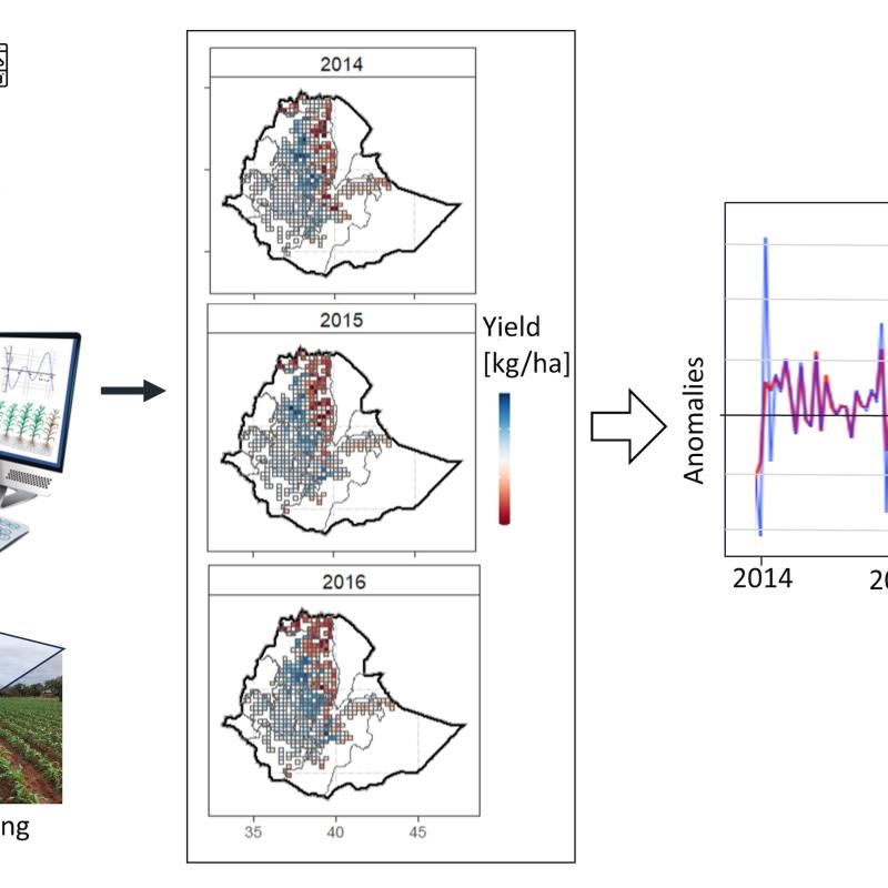
In many parts of the world, agricultural monitoring is hindered by limited field data, inconsistent surveys, and highly heterogeneous landscapes.

Beavers are often referred to as “ecosystem engineers” because their dam-building activity reshapes river corridors, alters local hydrology, and creates mosaics of ponds, wetland

Global prediction of anemia, stunting, and wasting using household surveys and geospatial covariates
This MSc project aims to generate high-resolution global maps of anemia, stunting, and wasting by combining biomarker and anthropometric data from DHS/MICS with globally consistent environmental, a

The arid and semi-arid lands (ASALs) of northern Kenya face pressing challenges due to climate change, environmental degradation, and socio-economic vulner

The estimation of canopy height, AGB and its changes is typically carried out using active Remote Sensing data such as LIDAR or Interferometric Synthetic Aperture Radars (InSAR)

Mediterranean thermophilous pines, which are the key, dominant, and characteristic species of this habitat, form some of the most drought-resilient woodlands in Europe.

Sufficient nutrition remains a major challenge for rural households in the Sub-saharan region of Africa.

The arid and semi-arid Lands (ASALs) of northern Kenya are characterized by extremes of poverty and climate.

Crop nutrient concentrations result from the interactions between soil fertility, plant nutrient uptake, and crop growth.

Recently, mortality and reduction in forest stand densities for Brutia pine (Pinus brutia) have been found ov
Food insecurity is a big issue in eastern and southern Africa and projections are that this is going to get worse with climate change and variability.

Forests are among the most diverse ecosystems on our planet.

Understanding how crops and grasslands respond to drought and weather extremes requires observations at multiple scales.

“Nature-based solutions” (NBS) or “building with nature” have received global attention as a multidimensional approach to reduce impacts of climate change and associated meteorological disaster ris
Behind the many different data sources available to innovate geospatial technologies and methodologies are large data infrastructures needed to produce and process geospatial data.

As an essential part of food security, diet diversity often requires frequent household food security surveys to monitor.

HANPP estimates the actual biomass production (Net Primary Productivity or NPP) following anthropogenic intervention.

The livelihoods of many people in the East African drylands heavily depend on livestock.

Bark beetle outbreaks have transformed large areas of Central European spruce forests, including the Bavarian Forest National Park.

Environmental data is often rich and complex.

Due to climate change, urban environments are becoming warmer. Residents may go to urban parks to cool off if their apartments are too hot (Wong et al., 2024).

Smallholder farming systems in Sub-Saharan Africa frequently involve intercropping, where multiple crops are grown together on the same parcel.

Drones or UAVs are revolutionizing conservation and agricultural practices, offering cost-effective and safe methods for data collection over large, challe

Droughts are exacerbated by climate change, which makes them more frequent, prolonged, and catastrophic.

Population growth around volcanoes exposes millions of people worldwide to the risks of volcanic activity.