Risk Mapping of Visceral Leishmaniasis Infections in West Pokot, Kenya: Characterisation of Local Environmental Risk Factors
To be started as soon as possible (spring 2023)
This topic can also be taken as an internship
Background
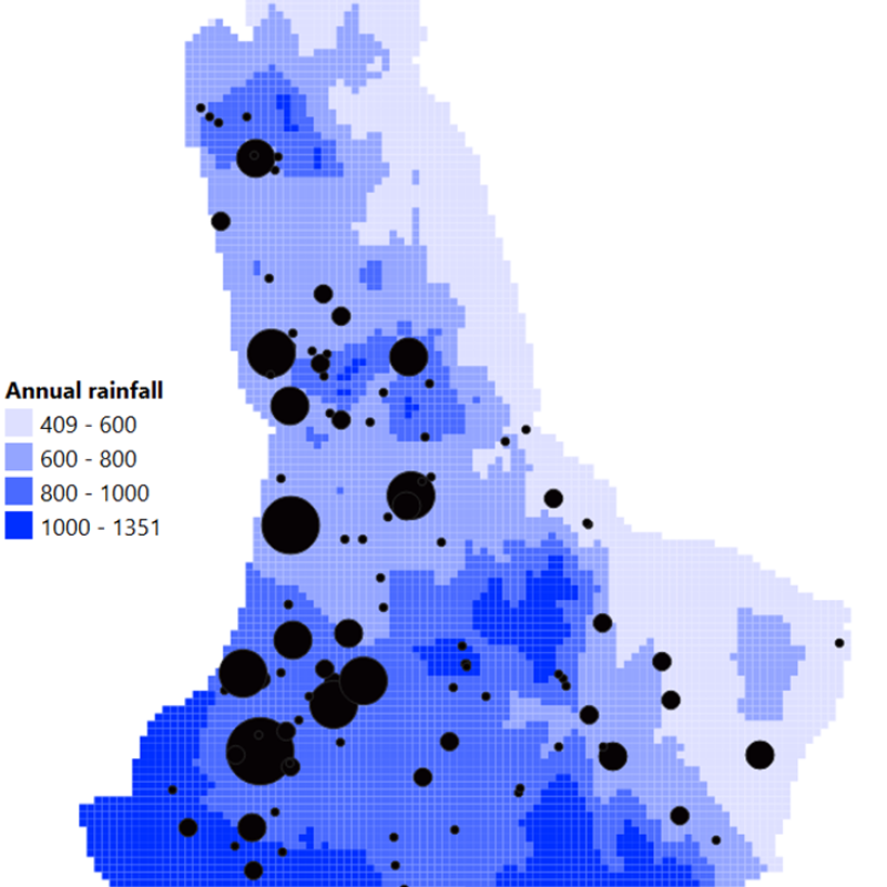
Visceral leishmaniasis (VL), also known as kala-azar, is a deadly parasitic disease caused by an infection with the protozoa Leishmania. This vector-borne parasite is transmitted by blood-feeding sandflies. An important VL hotspot is located in the Kenyan county of West Pokot. VL incidence in this area tends to fluctuate over the years, but case admission to the regional kala-azar hospital of Kacheliba has been increasing over the past decade. Besides the temporal variations in VL incidence, the spatial distribution of the disease also appears to vary considerably. These variable numbers of kala-azar infections might be explained by differences in environmental factors influencing the risk of acquiring the disease. Indeed, it is well-known that transmission rates of VL are highly dependent on the presence of favorable environmental and climatic conditions for the insect vector. The endemicity of VL in West Pokot is partly attributed to its semi-arid climate, where the local VL vector, the sandfly Phlebotomus martini, is believed to lay its eggs in the ventilation shafts of termite mounds. However, termite mounds are far more widely distributed in East Africa than P. martini. Thus, it appears that the habitat of this sand fly species relies on a specific combination of environmental factors, which remain to be elucidated. Identification of these factors is warranted, to increase awareness and guide the implementation of targeted control strategies. The techniques of Remote Sensing (RS) and Geographical Information Systems (GIS) have proven to be suited for mapping vector-borne diseases like VL, and for assessing environmental elements that influence their spatial distribution. In remote regions where field-based environmental data is inaccessible, RS and GIS are especially valuable.
Objective
To identify geographical and environmental risk factors associated with VL infections in West Pokot, Kenya, and build an eco-epidemiological prediction model to map the incidence and distribution of VL infections in West Pokot in relation to these risk factors. From a technical perspective, there are some challenges to be addressed. We only have positive cases (patients with VL), and no negative cases are available. The combination of two different datasets might be another challenge.
Study
The research group Experimental Parasitology of the Amsterdam UMC has conducted a field-based study at the Kacheliba Sub-County Hospital into VL in West Pokot, Kenya. This study took place between October and December 2022.
In order to map the incidence and spatial distribution of VL in West Pokot, paper case management forms from VL patients admitted to the Kacheliba Sub-County hospital in the period 2018 to 2022 were used to retrospectively collect data on their place of residence and the date of their VL diagnosis at the clinic. Similar data are available in a dataset from Médecins sans Frontières for the period 2000-2010.
Analysis of the retrospective data on VL patient distribution and the RS and GIS datasets will enable identification of environmental factors associated with increased risk of VL infections. These associations will form the basis for the development of an eco-epidemiological prediction model for VL in West Pokot.
This Project can be conducted as an MSc topic or Internship (Amsterdam UMC)
During this research project, the intern/MSc student will be responsible for:
- Cleaning and processing of datasets on VL patient distribution in West Pokot
- Identification and collection of GIS and RS data on environmental factors that are potentially associated with VL risk in West Pokot. These factors will include, but not be limited to, temperature, rainfall, vegetation, land cover, land use, and human geography.
- Analysis of VL, GIS and RS data
- Developing an approach to address the technical challenges (only positive cases and integration of two datasets).
- Development and testing of an ML (Machine Learning) eco-epidemiological prediction model for VL in West Pokot.
Timing
We are looking for a student or students that are willing to start in spring 2023.
Contact
If you are interesting in this topic, you may contact Ellen-Wien Augustijn (p.w.m.augustijn@utwente.nl) and Norbert van Dijk (Amsterdam UMC): n.j.vandijk@amsterdamumc.nl
Objective
To identify geographical and environmental risk factors associated with VL infections in West Pokot, Kenya, and build an eco-epidemiological prediction model to map the incidence and distribution of VL infections in West Pokot in relation to these risk factors. From a technical perspective, there are some challenges to be addressed. We only have positive cases (patients with VL), and no negative cases are available. The combination of two different datasets might be another challenge.
The topic addresses a process in system earth and analyzes physical and environmental processes from a technical perspecitve.