Regional crop yield assessment with Sentinel-2 and MODIS for the Netherlands
The topic is open for also suitable for GEM students in track 1 – GEM for Urban-Rural Interactions.
The topic is open for also suitable for GEM students in track 3 – GEM for Ecosystems & Natural Resources.
Suggested elective: Quantitative Remote Sensing of Vegetation Parameters.
The student should have good technical skills, including scripting/programming. Working experience with Google Earth Engine is a benefit.
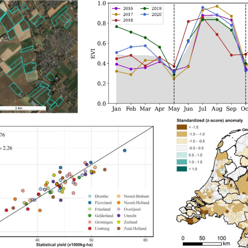
Regional prediction and forecasting of crop yield is important for analyzing food security and mitigating risks of food price volatility. Many countries have methods to come up with annual agricultural statistics (on cropped area, production, and yield), which in most cases rely on in-situ observations. However, such information is often only available at coarse spatial aggregation levels and is not very timely. Crop models fed by gridded meteorological data, but also remotely-sensed indicators of crop performance can be a useful means for estimating crop yields over large areas. For remote sensing, particularly vegetation indices such as the NDVI are often used, which can be translated into anomalies. To capture anomalies effectively, longer time series with coarse spatial resolution, such as from MODIS, are normally used. However, when fields are small, MODIS may not be effective in getting a representative VI profile for a specific crop in a region, due to mixed pixel effects. The main hypothesis to be tested in this study is whether crop-specific Sentinel-2 VI profiles allow for more accurate prediction on crop yield variability in the Netherlands (2016-2023) as compared to MODIS. Annual field boundaries with crop information for the Netherlands (Basisregistratie Gewaspercelen) are available to focus the analysis on specific crops. The suggestion is to include at least maize and wheat, and possibly extend to sugar beet and potato (i.e. the most important crops in the Netherlands).
The objectives of this study are:
- to derive crop- and province-specific temporal profiles of vegetation indices (VI) separately for Sentinel-2 and MODIS imagery;
- to assess if the VI profiles allow for accurate prediction of recent crop yield variability;
- to evaluate the difference in accuracy between predictions obtained from the two satellite sources.
The study builds on a previous MSc study that focussed on a single crop (maize) and Sentinel-2, but with promising results. The topic will take advantage of existing annual (farmer-reported) crop maps to build crop-specific VI profiles for each of the 12 Dutch provinces. To do this for MODIS, a technical challenge will be to translate the crop maps into 250m resolution fractional crop maps (for each year and crop) in order to make a fair comparison.
https://essay.utwente.nl/88780/ (MSc thesis by Kingkan Chamnan, 2021)