Modelling the distribution of the extremely rare Buxbaumia viridis moss species in the Rhodopi’s, Bulgaria based on remote sensing proxies
The topic is open for also suitable for GEM students in track 3 – GEM for Ecosystems & Natural Resources.
Suggested elective: Species distribution and environmental Niche Modelling.
Fieldwork could be possible, depending on when the student is ready with the proposal defence. This is however not absolutely necessary as all the data has already been collected. Alternatively, an independent internship in the same or similar location in Bulgaria, in collaboration with the Bulgarian counterpart can we considered.
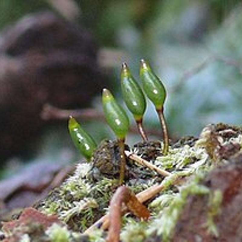
The moss species of Buxbaumia viridis is a rare moss species that lives mainly on dead wood that is in a high state of decay, with a strong preference for wood from coniferous tree species like Picea abies and Abies alba. Because of its “vulnerable” status according to EU law, European countries are required to monitor and report on the status of the species. However, because of its rarity and inconspicuous appearance, only few observations are available. mapping areas where the species could occur (potential habitat) would be helpful to direct the search and increase the number of observations, but it requires quite some effort to create those maps. Linking existing observations to remote sensing data can offer a solution to create larger extent (potential) distribution maps of this species. Currently, it is still unclear which remote sensing based metrics can be used to map the (potential) habitat. This topic aims to give an insight into the potential habitat range of this rare and endangered species, using remote sensing.
This MSc topic aims to identify the most relevant remote sensing based proxies that can be used to create suitability maps for the endangered and rare moss species Buxbaumia viridis. The research will use species distribution modelling techniques, in combination with potentially relevant forest metrics derived from Very High Resolution satellite imagery to create a better understanding how we can create such maps. This will build upon earlier work in the area by an ITC alumnus who assessed methods to create relevant forest metrics from VHR imagery in the same area.
There are roughly 80 observations in the area of the Rhodopi mountains, that are distributed over ~20 forest stands, which are rather homogeneous in structure. There are another 60 identified forest stands across Bulgaria for which presence of the species is confirmed by a species specialist. For these forest stands information is available on the structure of the forest as described by the stand age, average DBH, growing stock and canopy closure. The boundary of every forest stand is available as a polygon file.
Former student thesis as referenced in the text: http://essay.utwente.nl/92026/1/Hossain_s2551209_M-Geo.pdf
A key paper that made a first attempt to model the species with SDM’s in the Alpine region of Italy, but without the use of remote sensing: https://doi.org/10.1080/11263504.2015.1056858