Deep Learning based multisource data fusion for detecting deforestation
Required skills:
1) Programming skills in python.
2) Willingness to learn deep learning frameworks (TensorFlow, PyTorch)
3) Willingness to learn the manipulation of geographical data in Python (GDAL, geopandas, shapely, rasterio, etc)
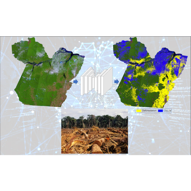
An accurate method for automatically mapping deforested areas constitute an important tool to inform and enable deforestation containment policies. With the recent increased need on reducing the loss of biodiversity and consequently, mitigating the effects of climate change, producing an automated, accurate and quickly responsive deforestation detection systems has become a hotspot research field. For this purpose, a wide range of ground truth data, with potential to be used as training data is available for South America, such like those produced by the Brazilian National Institute for Space Research (INPE) through PRODES (Amazon Deforestation Monitoring through Satellite Imagery system) and DETER (Near Real-Time Deforestation Detection System) systems, and by MapBiomas initiative through the MapBiomas Alerta system. Deep Learning models have demonstrated promising results for composing such methodologies. However, most approaches are based only on optical imagery, and hence are highly affected by cloud coverage and other atmospheric effects, and a few approaches are based on SAR. In addition, contextual data, like distance to roads or rivers have strong potential to improve the accuracy, once those structures are catalyzers of the deforestation process. Therefore, investigating multimodal approaches able to fuse data from different sources still a gap to be explored. For this topic, the student must have good programing skills.
The overall goal of this research is to develop deep learning based methods to compose a multimodal classifier for detecting changes on Land Use and Land Cover, especially those changes caused by the suppression of the vegetation (deforestation). Starting points are the late-fusion U-Net proposed by Maretto et al. (2020), and another multimodal/multi-path deep neural network composed of multiple networks and optimized by a combined loss function. Data from different sources, e. g., SAR and optical imagery and/or contextual data, like the roads and river networks might be fused for obtaining a better final result.
[1] R. V. Maretto, L. M. G. Fonseca, N. Jacobs, T. S. Körting, H. N. Bendini and L. L. Parente, "Spatio-Temporal Deep Learning Approach to Map Deforestation in Amazon Rainforest," in IEEE Geoscience and Remote Sensing Letters, doi: 10.1109/LGRS.2020.2986407. [2] MARETTO, R. V. “Automating land cover change detection: a deep learning based approach to map deforested areas”. 2020. 80 p. PhD Dissertation (Doctorate in Applied Computing) - Instituto Nacional de Pesquisas Espaciais (INPE), São José dos Campos, SP, Brazil, 2020. Available in: <http://urlib.net/rep/8JMKD3MGP3W34R/42L55PP>.